David Freeze: Concluding the mountain portion of state parks
Published 5:00 am Sunday, August 11, 2024


|
Getting your Trinity Audio player ready...
|
Editor’s note: David Freeze is a runner, running coach and long-distance cyclist from China Grove in Rowan County. He is visiting all 42 state parks in North Carolina. Contact him at [email protected].
By David Freeze
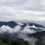
After seeing a long-distance view of Mt. Mitchell in the clouds the night before, I was still hopeful of reaching the summit in time to see the July 24 sunrise. Still 16 miles away at my motel, I left on the dark and damp morning at just after 6 a.m. I followed the Blue Ridge Parkway to the entrance road for Mt. Mitchell State Park and found most of it socked in by clouds.
Mt. Mitchell was the first N.C. state park in 1915 and is one of the smallest at 1,855 acres. It is named for Elisha Mitchell who explored the mountain and determined it the highest peak east of the Mississippi River at 6,684 feet. A railroad once operated on the mountain for logging purposes.
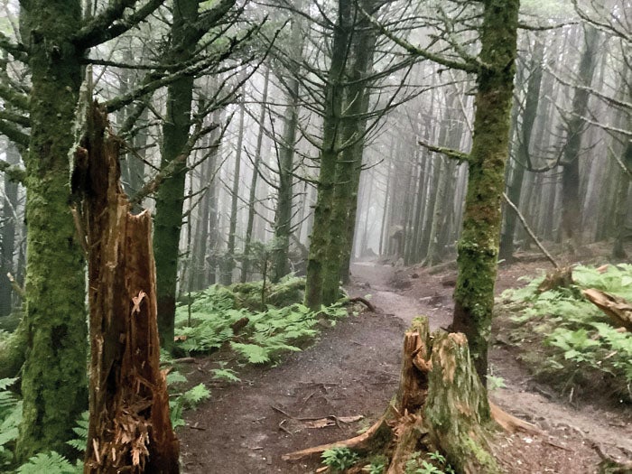
Highway 128 is the entrance road, and I drove to the summit parking area while waiting for more daylight and a hopeful break in the clouds. I realized the area was enveloped in a cloud, so I walked the Balsam Nature Loop as suggested by the owner of Albert’s Lodge the evening before. What I found was sort of an enchanted alpine forest, well worth the effort. At the far end, I walked briefly for the first time on the Mountains to Sea Trail which crosses North Carolina.
Back at the trailhead, I walked up the paved but steep Summit Trail to the observation area, I’m sure a real treat on a clear day. I was last here as a small child but couldn’t see more than 200 feet currently. A small museum and gift shop, plus restrooms are in the area, too. The museum has a life-sized figure of area explorer Tom Wilson and his cabin.
On the way back down, I stopped at the park restaurant that came highly recommended, but it didn’t open until 11 a.m. Last was a stop at the visitor center for my passport stamp and a map, plus an interesting conversation with one of the attendants. I will return to see the views that offer parts of four states and are so spectacular, maybe even Russia, according to Van at Albert’s Lodge with a smile.
My next park was South Mountains State Park, listed as nearest Connelly Springs and the largest state park at over 20,000 acres. The park has elevations of 3,000 feet and has 47 miles of hiking trails, 35 miles of equestrian trails and 17 miles of bike trails. Opened in the 1970s, the park has primitive camping. The Cherokee Catawba Indians once hunted and fought in the park area and settlers came in the late 1700s. Gold was found in 1828, and 26,000 acres were logged before the state established the park.
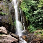
I asked at the visitor center about the most popular hiking trail in the park. The High Shoals Fall Trail is the signature trail and although the desk attendant suggested easier ones, I told her I wanted to see the falls. More than a mile to the falls, the second half was mostly wet rock steps. Four hundred of them this time, added to that a huge amount of people coming and going including what looked like kids’ day camps. I just stepped aside and gave everyone else plenty of room.
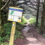
The park has an extensive mix of 11 hiking trails varying in distance from .2 miles to 5.2 miles and with varying degrees of difficulty. Many of the trails can be combined for even longer efforts. All of the trails leave from one of the three trailheads.
High Shoals Falls was one of the best I had seen on the state park trails, definitely again worth the effort. This was my 15th park and the most challenging waterfall trail yet. On the way back, I took another trail to Big Bear Falls with a much easier effort.
My next park was Lake Norman State Park, the closest to my farm, on July 26. The park opened in 1962 after Duke Power built the Cowans Ford Dam and then donated land for the park to the state. Lake Norman was created from 1959 to 1964, but the area is full of long-ago history. The Catawba Indians had a population of about 5,000 but they left the area after it declined to less than 100 because of disease and warfare with any of the eight other tribes close by. There is an interesting collection of arrowheads that have been carbon dated to before 2000 BC.
With 17 miles of shoreline on Lake Norman, the park has campgrounds, a public swim beach, hiking and biking trails, picnic areas and pavilions, a community building, a boat ramp and a fishing pier on its 1,328 acres. There is quality fishing in Lake Norman and the park lake. Kayaks, canoes, pedal boats and standup paddleboards are available in one of the smallest yet one of the best parks. There is a 30.5-mile Itusu mountain bike trail. I did the Lakeshore Trail, which is listed as six miles on the park map but closer to 5.6 miles. Two other shorter trails including one that is wheelchair accessible start near the visitor center. The beach is free except for a small charge to swimmers but boats can launch free on Boat Launch Drive. Campground sites are numerous with a bathhouse and restrooms nearby, while six new two-room cabins which can sleep six have water, sewer and electricity also available. Everything is free with lots to do!
Sixteen parks visited, and 26 more to go.